The Aral Sea Disaster: Why It Dried Up, Its Consequences, and Its Status Today
Once one of the largest inland bodies of water on Earth, the Aral Sea almost entirely disappeared within half a century. This is a factual explainer of the causes, consequences, and current restoration efforts.
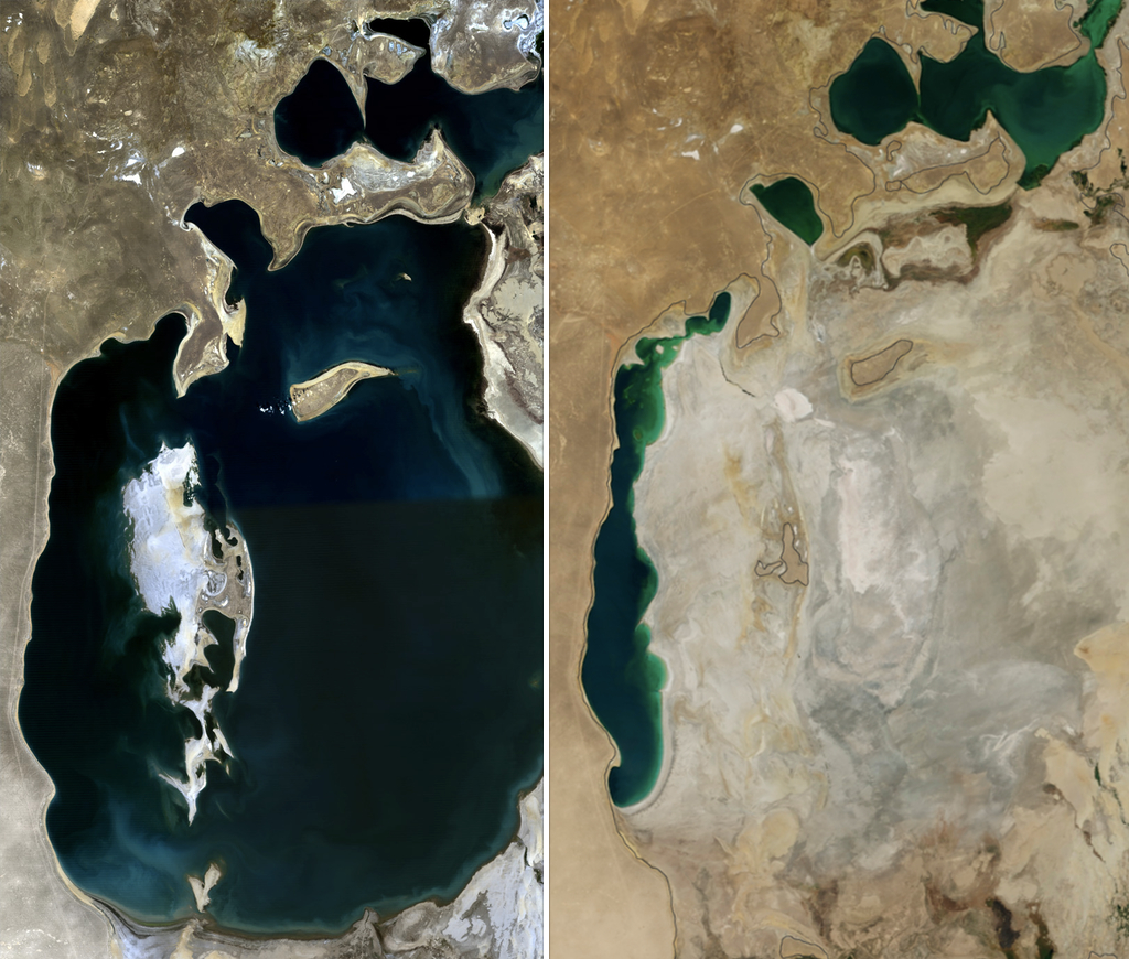
The Aral Sea is an endorheic (landlocked) body of water in Central Asia, shared between Uzbekistan and Kazakhstan. In 1960 it covered about 68,000 square kilometres and was the world's fourth-largest inland lake (Source: NASA Earth Observatory). Over half a century it lost more than 90 percent of its volume, in what has been described as one of the largest man-made ecological disasters in human history. This explainer sets out, in facts, why the sea dried up, what consequences it caused, and what is being done today to restore it.
What the Aral Sea Was
The Aral Sea was fed by two major rivers: the Amu Darya from the south and the Syr Darya from the north. Its western and southern shores belong to Uzbekistan's Republic of Karakalpakstan, while its northern part lies in Kazakhstan. In 1960 the annual inflow to the sea was about 56 cubic kilometres, and in places its depth reached 40 metres (Source: Britannica; NASA Earth Observatory). The region was important for fishing, shipping, and for moderating the local climate.
The Cause: Diversion of the Rivers
From the 1960s the Soviet Union diverted the waters of the Amu Darya and Syr Darya through canals for large-scale irrigated agriculture across Central Asia, mainly cotton ("white gold") and rice (Source: NASA Earth Observatory). As a result, inflow to the sea collapsed: from about 56 cubic kilometres in 1960 to below 10 cubic kilometres a year by the 1990s (Source: Britannica). Once inflow could no longer offset evaporation, the sea level fell and its shores began to retreat.

The Stages of Shrinkage
The sea shrank steadily from the 1960s. Between 1987 and 1989 it split into two parts: the North (Small) Aral and the South (Large) Aral. The South Aral then itself divided into eastern and western lobes. By 2001 the connection linking the southern lobes had been severed, and the shallow eastern part retreated rapidly. The eastern basin shrank especially fast between 2005 and 2009, when drought limited and then cut off the flow of the Amu Darya. In 2014 the eastern basin of the South Aral dried out completely (Source: NASA Earth Observatory). The satellite image in this article compares exactly this change, showing the sea in 1989 versus 2014.
Consequences: Desert, Dust Storms, and the Collapse of Fishing
Where the water retreated, a new desert called the Aralkum emerged on the exposed seabed. Its surface is saturated with salt, pesticides, and fertiliser residues that winds lift into the air. By estimates, more than 75 million tonnes of toxic dust rise from the Aralkum each year, and it can be carried up to 500 kilometres away (Source: review of international environmental studies). Moynaq (Mo'ynoq), once a busy port town, now lies dozens of kilometres from the water, with rusting ships left stranded. As salinity rose and fish species vanished, fishing — the backbone of the regional economy — collapsed entirely.
Impact on Health, Climate, and Biodiversity
In Karakalpakstan, toxic dust and deteriorating drinking water have had a severe impact on public health: rates of respiratory disease, oesophageal cancer, and kidney and liver disorders rose sharply, and infant mortality became among the highest in the world (Source: international public-health research). The loss of a large water mass also changed the local climate, with hotter summers and colder, drier winters. Many plant and animal species, including fish of the sea and delta, were lost.
The Partial Recovery of the North (Small) Aral
Kazakhstan built the Kok-Aral Dam under the World Bank-financed Syr Darya Control and Northern Aral Sea project; the dam was completed in August 2005 (Source: World Bank). It allowed Syr Darya water to accumulate in the North Aral. As a result the water level rose by about 4 metres, salinity fell by roughly 50 percent, and the water moved closer to the town of Aralsk. Fish stocks returned and fishing partly revived; the North Aral filled faster than expected (Source: World Bank). This recovery, however, applies only to the smaller northern basin — the main body of the South Aral remains dry.
Current Status and Restoration Efforts
Uzbekistan is carrying out large-scale planting of hardy saxaul and other drought-resistant plants on the Aralkum to stabilise the dried seabed, with the aim of reducing dust storms and fixing the soil (Source: UNDP "Green Aral Sea"). Through the UNDP "Green Aral Sea" initiative, hundreds of thousands of saxaul seedlings have been planted on the exposed bed. In addition, on the initiative of the President of Uzbekistan and the UN Secretary-General, the UN Multi-Partner Human Security Trust Fund for the Aral Sea region was established in 2018; it finances clean drinking water, healthcare, sustainable business, and scientific research (Source: UN / UNDP MPTF). These efforts aim to soften the disaster's consequences, but a full restoration of the Aral Sea remains an unmet goal.

Sources
- NASA Earth Observatory — World of Change: Shrinking Aral Sea
- NASA Science — The Shrinking Aral Sea
- World Bank — Saving a Corner of the Aral Sea (Kok-Aral Dam)
- World Bank — Greening the Desert: Landscape Restoration in Uzbekistan
- UNDP / UN MPTF — Human Security Trust Fund for the Aral Sea Region
- UNDP Uzbekistan — Green Aral Sea Initiative
- Encyclopaedia Britannica — Aral Sea